The soft alluvial clay layer immediately beneath the seabed is a type of clay commonly found along coastlines, and over time, subsidence countermeasures have been implemented based on extensive knowledge and experience regarding its properties and mitigation techniques. At Kansai International Airport, ground improvement was carried out using the sand drain method.
On the other hand, the diluvial clay layers beneath it are unusually deep and sandwiched in structure, which makes ground improvement challenging. Therefore, the airport facilities are managed with the assumption that long-term subsidence will continue.
Subsidence Measures for Alluvial Deposits
Introduction of the Sand Drain Method
Due to the weight of Kansai International Airport island, the alluvial clay layer will subside to two-thirds of its original thickness. Since uneven subsidence could negatively impact the airport facilities, ground improvement was essential. Although it is impossible to prevent subsidence itself, by implementing ground improvement using the sand drain method, we successfully accelerated the subsidence artificially, completing a process that would normally take several decades within one year.
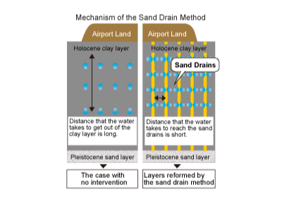
Mechanism of the Sand Drain Method
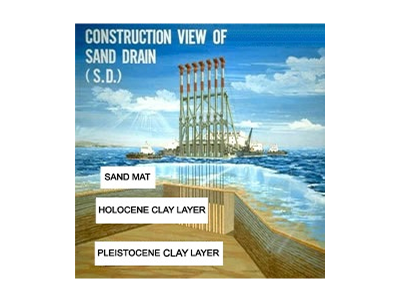
Mechanism of the Sand Drain Method Work Barge for the Sand Drain
Sand Drain Construction Results and Effectiveness
The sand drain method is a technique used to accelerate island subsidence by driving sand piles into the clay layers to improve drainage. On Phase 1 island, 1 million sand piles, each 20 m long and spaced 2.5 m apart, were installed, and on Phase 2 island, 1.2 million sand piles were installed. This scale significantly exceeds the total number of 900,000 piles installed nationwide over the 35 years from 1952 to the start of the Kansai International Airport construction. According to subsidence data since the start of construction, the sand drains performed as expected, and subsidence stabilized within one year of island construction. It can be seen that there has been almost no subsidence since then.
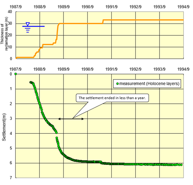
An example of Settlement of Holocene Layer
Subsidence Status of the Diluvial Deposits
Gradual Subsidence Progress under Natural Conditions
The currently ongoing long-term subsidence is occurring in the diluvial deposits. The diluvial clay layer is deep and thick, making ground improvement difficult, and subsidence is gradually progressing under natural conditions.
According to the subsidence data of the diluvial clay layer on Phase 1 island, during the reclamation period under water, the fill material was buoyant in the water, and the weight of the island did not exceed the strength of the diluvial clay layer, resulting in minimal subsidence. However, subsidence began once the reclamation emerged above the water surface. Initially, subsidence progressed rapidly, but it gradually slowed down, and in recent years, it has decreased to less than 10 cm per year.

An example of Settlement of Pleistocene Layer (Island 1 measurement point 17)
The diluvial layer is up to 400 m thick, and its properties vary significantly with depth. Based on characteristics such as sedimentation age and clay hardness, it is mainly classified into upper and lower layers.
Phase 1 Island — Current Subsidence Status (As of December 2024)
We have been observing settlement processes at 17 points since the beginning of the construction of the first island, including a study of the Holocene and Pleistocene layers. As previously mentioned, the process within the Holocene layer ended less than a year after the reclamation was complete, thus the settlement of the KIX island can be almost entirely attributed to the settlement of the Pleistocene layer.
The measurements made in December 2024 show that the depth of the settlement at each point varies depending on the thickness of the clay layer and the weight of the reclamation material. The average depth of the settlement since the beginning of the KIX construction is 13.66 m, and the depth of the settlement before the opening of KIX was 9.82 m.
The depth is decreasing 6 cm per year as of 2024.
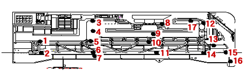
Subsidence measurement points
Phase 2 Island — Current Subsidence Status (As of December 2024)
On Phase 2 island, subsidence of the seabed has been measured at 54 points since the start of construction. These measurements indicate the total subsidence of both the alluvial and diluvial layers combined. Since subsidence in the alluvial layer had stabilized by the time Phase 2 island facilities began operation, subsidence after the start of operation is believed to be primarily caused by the diluvial layer.
According to measurements taken in December 2024, the average subsidence at 54 points over the past year was 21 cm. From the start of operations in 2007 to the present, the average subsidence has been 5.76 m, and the total subsidence, including 11.71 m from reclamation to the start of operations, amounts to 17.47 m.
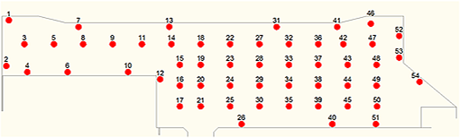
Subsidence monitoring point
To more accurately predict future subsidence, it is necessary to conduct a detailed analysis of the overall convergence trend, the impact of Phase 2 island on the sand layer's water pressure and long-term subsidence of Phase 1 island, as well as the subsidence convergence status of the diluvial layer. We will continue to carefully monitor the situation with ongoing accumulation of subsidence data and under the guidance of experts.